Clark Art Lecture on Reading Coastlines

Print Story | Email Story
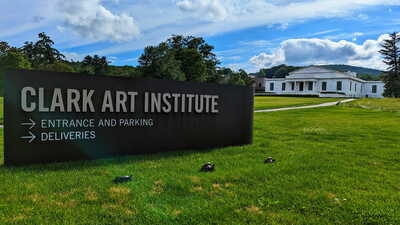
WILLIAMSTOWN, Mass. — On Tuesday, Nov. 18 at 5:30 pm, the Clark Art Institute's Research and Academic Program hosts a talk by Leslie Geddes (Tulane University / Clark Fellow) that examines how early modern cartographers taught others to see coastlines and read their contours in maps. 
 
The talk takes place in the Manton Research Center auditorium.
 
This talk makes Italian hydrography distinct by focusing on how early modern printed atlases shed light on the vast conceptual gulf between articulating known terrain versus cartographic imaginings of remote seas. More than collections of maps, atlases such as Robert Dudley's Arcano del Mare (“The Secrets of the Sea”) (Florence, 1646–47) incorporate volvelles and other paper instruments built into the book for the reader's experimentation and delectation. As manipulable objects, atlases served as a training ground for readers to learn principles of navigation and to read maps effectively. Atlases set the parameters for apprehending cartographic knowledge. The implications are nothing short of the limits of firsthand knowledge of the aquatic environment and its cartographic representation.
 
Leslie Geddes is the Jessie J. Poesch Assistant Professor of Art History at Tulane University. She is the author of "Watermarks: Leonardo da Vinci and the Mastery of Nature" (Princeton University Press, 2020). Her research focuses on how early modern artists studied and depicted the natural landscape. At the Clark, she will work on her second book, which examines how printed maritime atlases confronted the struggle to represent the ineffable. 
 
Free. Accessible seats available; for information, call 413 458 0524. A 5 pm reception in the Manton Research Center reading room precedes the event.

Tags: Clark Art,   

If you would like to contribute information on this article, contact us at info@iberkshires.com.

Williamstown's Cost Rising for Emergency Bank Restoration

By Stephen DravisiBerkshires Staff
WILLIAMSTOWN, Mass. — The cost to stabilize the bank of the Hoosic River near a town landfill continues to rise, and the town is still waiting on the commonwealth's blessing to get to work.
 
Department of Public Works Director Craig Clough was before the Finance Committee on Wednesday to share that, unlike the town hoped, the emergency stabilization work will require bringing in a contractor — and that is before a multimillion dollar project to provide a long-term solution for the site near Williams College's Cole Field.
 
"I literally got the plans last Friday, and it's not something we'll be able to do in-house," Clough told the committee. "They're talking about a cofferdam of a few hundred feet, dry-pumping everything out and then working along the river. That's something that will be beyond our manpower to do, our people power, and the equipment we have will not be able to handle it."
 
Clough explained that the cofferdam is similar to the work done on the river near the State Road (Route 2) bridge on the west side of North Adams near West Package and Variety Stores.
 
"We don't know the exact numbers yet of an estimate," Clough said. "The initial thought was $600,000 a few months ago. Now, knowing what the plans are, the costs are going to be higher. They did not think there was going to need to be a coffer dam put in [in the original estimate]."
 
The draft capital budget of $592,500 before the Fin Comm includes $500,000 toward the riverbank stabilization project.
 
The town's finance director told the committee he anticipates having about $700,000 in free cash (technically the "unreserved fund balance") to spend in fiscal year 2027 once that number is certified by the Department of Revenue in Boston.
 
View Full Story

More Williamstown Stories