
Nor'easter Set to Drop Foot of Snow Over Berkshires
Update on the powerful Nor'easter set to drop up to a foot of snow over the region. This come right on the tail Friday's storm that dropped up to 6 inches in some areas.
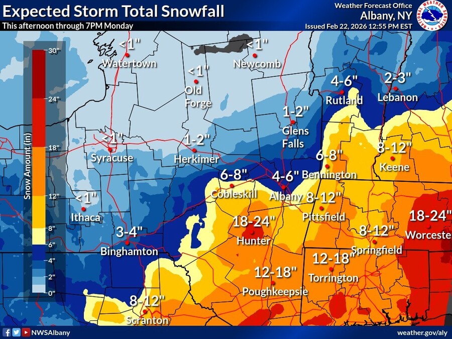
The National Weather Service in Albany, N.Y., has shifted the winter storm warning issued from Saturday a few hours later; it now begins at 4 p.m. on Sunday but still runs through 7 p.m. on Monday for the Berkshires, eastern New York, Southern Vermont and northern Connecticut.
Heavy snow expected with total accumulations between 8 and 14 inches with some locally higher totals possible over the high peaks of the Catskills AND the Berkshires. Winds could gust as high as 50 mph.
The forecasted "bomb cyclone" is lining up to hit New York City with its first blizzard in a decade, but Western Mass will feel some of its effects.
The Berkshires will see flurries during the day but the Nor'easter will make its entrance later in the evening, first in South County between 5 and 8 and then moving north.
Vermont schoolchildren will be starting their winter vacation Monday but Berkshire kids will be headed back to school. But they might be getting an extra vacation day — Greylock Snow Day still has an 80 percent probability for of delays, but upgraded the chance of a snow to 90 percent for South County and 75 percent for north.
With the storm sweeping in by Sunday afternoon, we'll be on the lookout for any cancellations. This post will also be updated if new information becomes available.
Pittsfield is implementing parking restrictions: park on the even side on Sunday through 7 a.m. Monday, then switch to the odd side through 7 a.m. Tuesday. Downtown residents are encouraged to use the McKay Street Parking Garage for overnight parking, free until Tuesday at 7 a.m. Note that trash and recycling pickup is canceled for Monday and will be on a one-day delay the rest of the week.
All Berkshire residents are reminded that most municipalities have winter parking bans in effect — no overnight parking on roadways to allow for plows to get through. Violators may be towed or ticketed.
Lenox has declared a snow emergency from Sunday at 10 p.m. to Monday at 4 p.m. Any vehicles parked on the roads will be towed.
North Adams has also declared a snow emergency and all public building swill be closed Monday. The Becket and West Stockbridge town halls will be closed.
Gov. Maura Healey has declared a state of emergency and directed non-emergency executive branch employees to work remotely on Monday. Emergency operations centers in Agawam, Tewksbury and Franklin will be activated Monday to assist communities; the governor has authorized the activation of up to 200 Massachusetts National Guard members to support storm response operations, particularly in flood-prone areas. Check out the #fleecealert for an indication of how bad this storm is expected to be.
Highway Districts have pretreated state roadways in advance of the storm and will be deploying snow removal crews and 3,000 pieces of state and vendor equipment to keep roads clear. Large trucks — box truck, tractor trailers, etc. — are prohibited from traveling interstates with few exceptions.
"With heavy snowfall forecast statewide and the potential for blizzard conditions, travel is expected to be dangerous during this storm," said State Highway Administrator Jonathan Gulliver. "We are implementing commercial truck restrictions beginning at 5 p.m. [Sunday], and all non-emergency vehicles should stay off the roadways until the storm has passed."
Accuweather is describing blizzard conditions affecting coastal areas and the I-95 corridor with up to 18 inches of snow, with rates of 1 to 3 inches an hour. It's expected to be heavy, wet snow that could make shoveling difficult and dangerous.
Temperatures, however, aren't likely to dip back into frigid territory and Tuesday will see clearing and sunnier skies.
Twenty-eight days to spring.
How serious an emergency? Both governor and #Boston mayor are in fleeces today.
— Boston French Toast Alert System (@bostonfrenchtoast.bsky.social) February 22, 2026 at 1:21 PM
[image or embed]
Blizzards are mostly defined by their winds. Sustained/frequent gusts of at least 35mph are needed as part of an official blizzard. This will be achieved in areas. Add in 2-3" an hour snow rates, and visibilities will be low (<0.25 miles needs to occur for a blizzard). #MAwx #CTwx #RIwx #NHwx #MEwx
— New England Storm Center (@nestormcenter.bsky.social) February 22, 2026 at 2:29 PM
[image or embed]
The blizzard starts tonight.
— Only In Boston (@onlyinbos.bsky.social) February 22, 2026 at 7:02 AM
[image or embed]
Tags: snowstorm,